Why Þingvellir Is Iceland's Most Important Place
For many visitors, the Golden Circle can feel like a high-speed checklist of Icelandic highlights. But Þingvellir National Park (Icelandic: Þjóðgarðurinn á Þingvöllum) is where that checklist gives way to something far more profound — a place where the literal foundations of the Earth and the historical foundations of a nation collide.
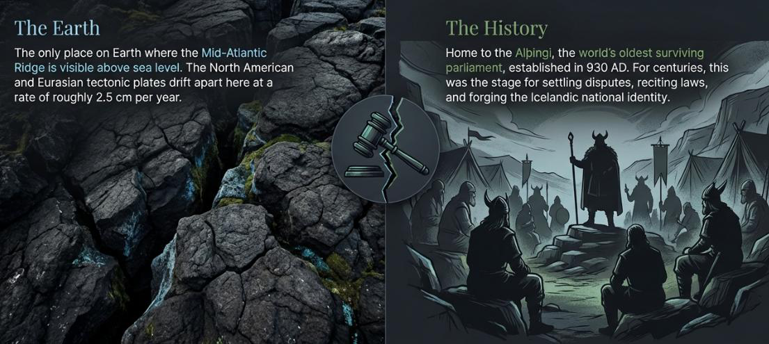
Þingvellir is where Iceland's national assembly, the Alþingi, was founded in 930 AD, making it one of the oldest parliamentary sites on Earth. For nearly nine centuries, chieftains and free Icelanders gathered each summer on the open plains beside the Öxará River. The ancient law-speaker would stand on a high cliff called Lögberg (Law Rock) and proclaim laws to the assembly — the natural acoustics of the rift walls acting as a megaphone to project his voice across the crowd.
This heritage makes Thingvellir Iceland's "national shrine" and a symbol of Icelandic identity. Landmark decisions made here included the adoption of Christianity in 1000 AD and, in 1944, the proclamation of the Republic of Iceland's independence. In 1930 — on the millennial anniversary of Alþingi — Þingvellir became Iceland's first national park, and today it holds UNESCO World Heritage status.
But history is only half the story. Þingvellir sits in a dramatic rift valley surrounded by lava fields, mountains, and Iceland's largest natural lake. UNESCO describes it as "a rift valley with its high cliffs" that forms a "magnificent natural backdrop" to the ancient assembly site. There is a relatable, almost childlike curiosity in the prospect of standing in two places at once — and at Þingvellir, that metaphor becomes a staggering reality.

Geology: Standing Between Two Tectonic Plates
Þingvellir lies in an active rift zone on the Mid-Atlantic Ridge, the divergent plate boundary running through Iceland. Here the North American Plate (to the west) and the Eurasian Plate (to the east) are literally moving apart — and the park sits directly on the seam.
The entire Thingvellir park is part of a graben (a sunken valley) between two great parallel faults: Almannagjá on the west and Hrafnagjá on the east. Over millennia this rift valley has widened — the land between the faults has subsided by roughly 40 metres in the past 10,000 years. The Iceland tectonic plates creep apart at a rate of 2 to 2.5 centimetres per year, meaning the park you stand in today is measurably wider than the one the Vikings settled.
This makes Þingvellir one of the only places on Earth where you can see the effects of diverging tectonic plates on dry land. The Almannagjá gorge — roughly 9 km long with 30-metre basalt walls — is often cited as a textbook example of plate tectonics. Walking between those towering walls of black volcanic rock, you are occupying the "seam" of the world. It is a humbling, visceral reminder that our planet is not a static stage but a living, breathing entity, tearing itself apart even as you walk its surface.
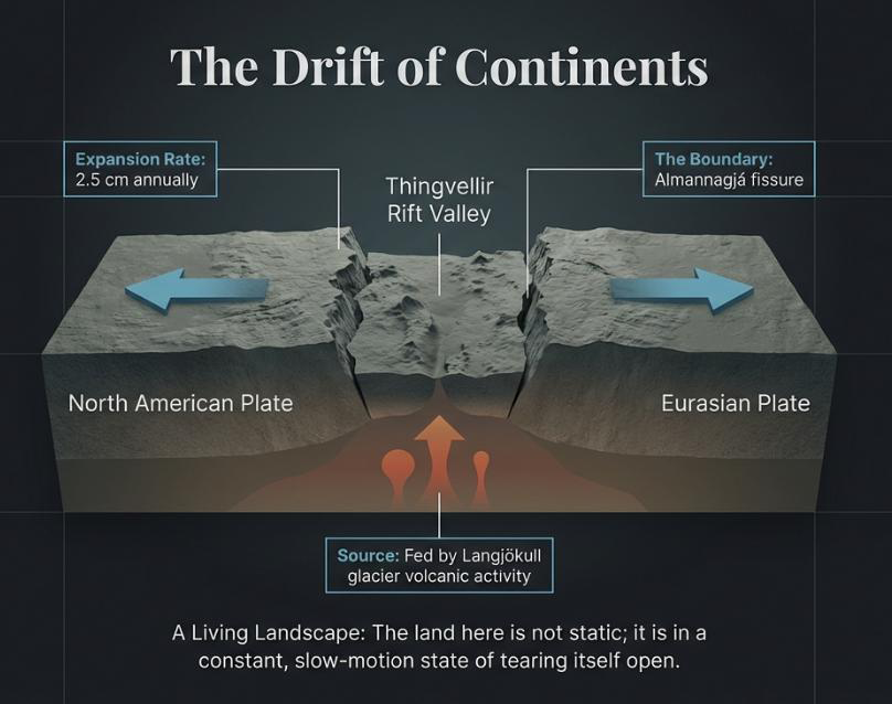
About 10,000 years ago, the Þingvellir area was covered by thick lava from the Skjaldbreiður volcano. Later, powerful crustal shifts and earthquakes created the deep depression and dual fissures you see today. The floor of the rift valley has sunk some 3–4 metres since the 930 AD assembly began.
Top Thingvellir Attractions
The attractions at Þingvellir span historic landmarks and extraordinary natural features. Here are the highlights not to miss:
Hakið Viewing Platform (Visitor Centre, P1)
Located beside the Visitor Centre, this wooden deck overlooks the Assembly Plain and Almannagjá gorge. It offers one of the park's best panoramic vistas — looking out across the rift valley, Lake Þingvallavatn, and the surrounding mountains. The Visitor Centre itself has exhibits on Þingvellir's history and geology, plus restrooms and a small shop.
Almannagjá Gorge and Law Rock (Lögberg)
A boardwalk trail leads from Hakið down into the gorge. Almannagjá (meaning "Everyman's Gorge") is where the Law Rock stood — the natural platform where the law-speaker of Alþingi announced laws to the assembly. The rock's location is marked, and following the gorge path on sturdy wooden decking, you can walk alongside the crevice between the tectonic plates. Most visitors pause here 10–20 minutes to soak in the history and take photos with the rift valley Iceland Thingvellir fissure behind them.
Öxarárfoss Waterfall
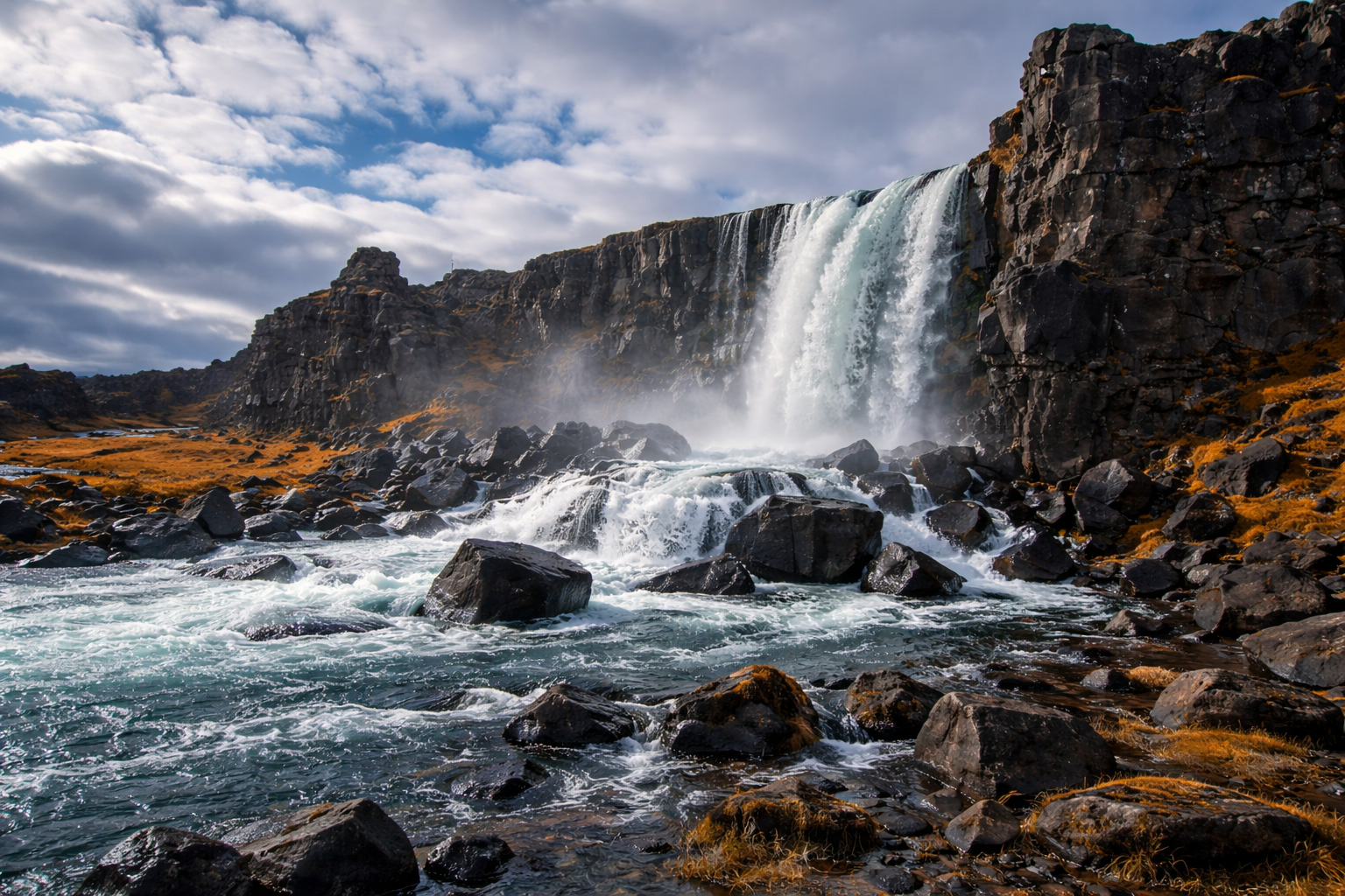
Þingvellir's only major waterfall, where the clear Öxará River tumbles over black basalt into a rocky pool. A short, easy trail from parking area P2 (or via the boardwalk loop from Hakið) leads to viewing platforms at the falls. Historically, the waterfall was partly man-made — the river was redirected at Alþingi's request, dating back to 11th-century sagas. Öxarárfoss is especially scenic after rain or snowmelt, and in winter, ice forms dramatic columns along the cliff. Plan roughly 20–40 minutes here.
Þingvallavatn Lake and Þingvellir Church
To the south of the main park lies Lake Þingvallavatn, Iceland's largest natural lake at 84 km². It is a closed ecosystem where species have evolved in isolation since the last ice age — most notably, four distinct varieties of Arctic char that diverged from a single ancestor to fill different ecological niches. From parking P5 (Valhöll), a short flat trail leads to the lake's edge and the wooden Þingvallakirkja (dating to 1859) nearby. On a calm day the lake's glassy surface mirrors the valley rim.
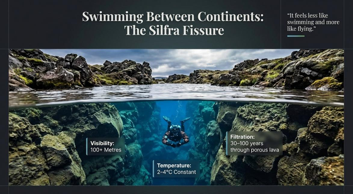
Silfra Fissure — Snorkeling Between Continents
The Silfra fissure at P5 is world-famous among divers and snorkelers. It is a submerged rift between the plates, filled with glacial meltwater from the Langjökull glacier that has spent 20–30 years filtering through porous lava rock. By the time it reaches Silfra, it possesses an impossible clarity — visibility exceeds 100 metres, making it one of the clearest bodies of water on Earth.
The water temperature holds at a steady 2–4 °C year-round, meaning high-quality drysuits are mandatory. While the fissure reaches depths of 60 metres, the National Park strictly regulates diving to a maximum depth of 18 metres for safety. A guided snorkeling or diving tour in Silfra lets you literally float between two continents.
Other Sites Worth Exploring
Beyond the main highlights, look for the Þingvallabær farmhouse (warden's house) by the church, historic ruins like Skógarkot and Hrauntún, and the Drekkingarhylur pool in the Öxará — a medieval outcasting site. The storied Leggjabrjótur trail ("Leg Breaker"), a 16 km ancient bridle path through the pass between Botnssúlur and Búrfell mountains, ends in the remote Hvalfjörður fjord — a rugged adventure for experienced hikers.
Best Walks in Þingvellir National Park
Þingvellir offers walking routes for all levels, from easy scenic loops on boardwalks to longer summit hikes. Paths are well-marked and the heritage area (Almannagjá and Öxarárfoss) is accessible to most visitors. Here is a comparison of popular hiking routes:
| Trail (Start) | Distance | Duration | Difficulty | Highlights |
|---|---|---|---|---|
| Almannagjá → Öxarárfoss Loop (P2) | 4.8 km | ~2 hr | Moderate | Almannagjá gorge, Law Rock, Öxarárfoss waterfall |
| Almannagjá Boardwalk (P1/P2) | 4.2 km | ~1.5 hr | Easy | Gently sloping boardwalk through rift, Law Rock |
| Vatnskotsvegur Loop (P5) | ~4.0 km | ~1.5–2 hr | Moderate | Skógarkot farm ruins, birch woods, birdwatching |
| Þingvellir Loop (Sandhóll) (P3) | 10.8 km | ~3.5–4 hr | Moderate | Lake Þingvallavatn shores, Silfra fissure area |
| Þingvellir → Öxarárfoss (P1→P2) | 7.9 km | ~2.5–3 hr | Moderate | Öxarárfoss waterfall, tectonic rifts |
| Arnarfell Summit (via Svartagil, P3) | 12.6 km | ~4 hr | Hard | 360° panoramic view of park and lake |
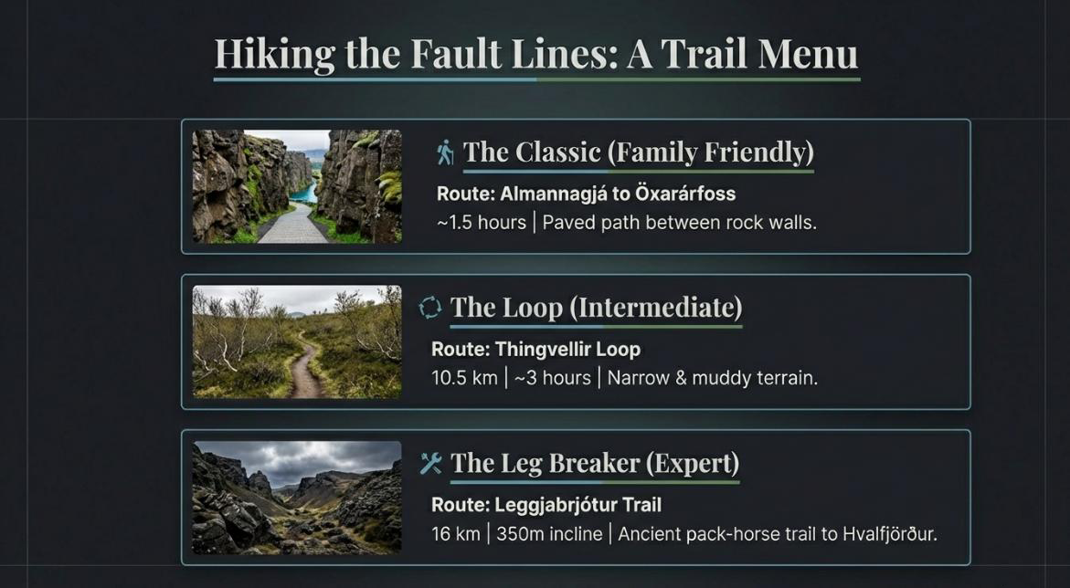
The Almannagjá Boardwalk is the best family-friendly option — easy, flat, and beautifully scenic. For experienced hikers, the Arnarfell Summit trail climbs to 700 m and rewards with a complete panorama of Þingvellir and Þingvallavatn. Trail conditions vary by season: in winter many paths are snow-covered and best attempted with crampons or spikes.
Þingvellir Parking and Access
Þingvellir is easily reached by car via Route 36 from Reykjavík (a straightforward 45–60 minute drive). There is no direct public bus from the capital to the park, so most visitors either drive or join a Golden Circle tour. The park is open year-round, 24/7, with no gate closures.
Parking Fees
The park operates a paid parking system (a daily service fee). As of 2026, fees are roughly 1,000 ISK per passenger car (up to 5 seats) per day — approximately £6–7. Larger vehicles and buses pay more. Payment is via license-plate recognition: machines at P1, P2, and P5 accept payment, and you can also pre-pay online using the Parka app or Checkit.is. Cameras use automatic plate recognition — failing to pay within 24 hours results in significant late fines. Disabled badge holders park free (register plates at the Visitor Centre).
One payment covers parking in any lot (P1–P5) for the entire day — you don't need to pay again when moving between areas.
Parking Areas
- P1 (Hakið): By the Visitor Centre and viewing platform. The main lot for Almannagjá and exhibits.
- P2 (Öxarárfoss): Lower lot near the Öxarárfoss waterfall trail.
- P3 (Langistígur): About 900 m north of Öxarárfoss, used for longer hikes.
- P5 (Valhöll): Close to Þingvallakirkja (church) and the Silfra/Davíðsgjá dive area.
Each lot has heated restrooms and payment machines. There is ample signage, and well-signed roads (Route 36 and local roads) lead into each parking area.
Getting There
Þingvellir lies on the Golden Circle route between Reykjavík and Geysir/Gullfoss. A rental car is essential since there is no public transport to the park. The drive from Reykjavík via Route 36 takes about 45 minutes in good conditions. Within the park, sights are connected by short footpaths — from P1 you can walk into Almannagjá, while P2 and P5 are a few minutes' drive from each other.
Practical Tips for Visiting Thingvellir
Opening Hours
The park area itself is always open, but staffed facilities have set hours. The Visitor Centre (Hakið) is typically open daily 09:00–18:00 (April–October) and 09:00–17:00 (November–March). The Service Centre (Leirar) near the campgrounds is open 09:00–18:00 (May–October) and 09:00–17:00 (November–April). The Service Centre has a café serving light meals, snacks, and hot drinks.
Facilities
Toilets are available at the Visitor Centre/P1, at P2, and at P5 (Valhöll). No dining facilities exist on the far side of the park — pack food if you're planning longer hikes. Gift items and guidebooks can be found at the Visitor Centre shop. Mobile signal is intermittent throughout the park.
Accessibility
Many popular areas have wooden boardwalks. The Almannagjá path from Hakið is raised decking — wheelchair-possible, though steep in places. The parking lots and terrain can be uneven, and some gaps exist between paving slabs. The Visitor Centre has step-free access.
Weather and Safety
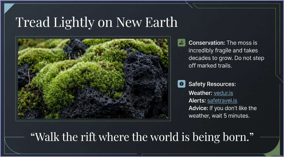
Iceland's weather is notoriously unpredictable. Dress in layers and bring waterproofs and sturdy boots. In winter or early spring, trails can be icy and snow-covered — park staff strongly recommend crampons or Yaktrax, especially when heading to Öxarárfoss. No fenced barriers exist along many cliff edges, so supervise children closely. Be aware that Þingvellir lies in an active seismic zone — small quakes are common — but no visitors have ever been harmed. Always check road conditions at road.is before driving.
Suggested Itineraries
Half-Day Tour (3–4 hours)
Full-Day Adventure (6–8 hours)
Combine the half-day route with the full Thingvellir Loop (10.8 km via Sandhóll) for wide lake views and the Silfra area. Or drive back to P3 and tackle the Arnarfell summit for 2+ hours of panoramic rewards. If you have booked a Silfra snorkeling or diving session, schedule it from P5 in the afternoon. Finish the day continuing along the Golden Circle to Geysir and Gullfoss.
Family-Friendly Visit (2–4 hours)
Concentrate on the assembly site and waterfall. Kids love the boardwalk and waterfall. Stay around P1–P2: walk through Almannagjá (easy, flat) and visit Öxarárfoss. Bring a picnic by the lake near the church (P5) if time allows. Avoid long, hard hikes with young children.
Frequently Asked Questions
Yes — there is no entrance fee. The only charge is a parking service fee of approximately 1,000 ISK (~£6–7) per car per day, which is valid across all five parking lots.
As of 2026, parking costs roughly 1,000–1,200 ISK per passenger car per day. Larger vehicles and buses pay more. Payment is via license-plate recognition machines or the Parka app / Checkit.is. One payment covers all lots (P1–P5) for the entire day.
Drive via Route 36 — it's about 45–50 km northeast of Reykjavík (45–60 minutes by car). There is no direct public bus, so most visitors drive or join a Golden Circle tour.
Yes — snorkeling at Silfra requires no prior dive experience. You'll wear a drysuit and float on the surface with a guide. However, all visitors must book a guided tour with a licensed operator. The water is a steady 2–4 °C year-round.
Dress in warm, windproof layers with waterproof outer shells and sturdy hiking boots. In winter, crampons or Yaktrax are strongly recommended as trails can be icy. Conditions change rapidly, so always bring rain gear even in summer.
Plan at least 2–3 hours to see the main highlights (Almannagjá, Law Rock, Öxarárfoss, lake viewpoint). A full-day visit allows for longer hikes and a Silfra snorkeling session. Family visits typically need 2–4 hours.